
Recently Messner has been searching for new mountains to climb and GBH was one of them. In fact, we have been talking about wanting to climb this mountain for a long time but never really got to it because of the difficulty in getting to the base of the mountain. Messner, as usual, did his research through the internet and and got some contacts. He scouted the facilities at the base, talked to the guides there and made a rough itinerary in his head before recruiting climbers.
About 4 weeks before the climb, Messner asked a group of us if we were interested in climbing GBH. Along with the email, he included a detailed itinerary and all the necessary details of the climb. Like Belumut, I was a bit hesitant. The climb was supposedly as tough as Nuang. 6 hours up and 4 hours down. I wasn't sure whether I wanted to torture my poor feet again. See, I've this pair of Timberland which I use for hiking and they hurt the soles of my feet after the 6th hour. Having mixed feelings, I just added my name in, paid a deposit of RM60 and hope that I would be fit enough for the climb.
Was I fit enough? Nope, I don't think so. See, for the first 3 weeks since I received the email, I was having bad headaches which prevented me from hiking our local Kepayang Hill. Whenever I could, I'd brisk walk round the Lake Gardens or cycle in the gym. That was all the training I did for GBH. And oh yeah, one week before the climb, I walked up and down my house staircase a hundred times. :D Well, not all at once, but I stopped & rested at every 10 rounds. It took me roughly about 2 hours. That goes to show how long my breaks were in-between the 10s. :D But for the next 4 days, my calves hurt like crazy. It was so difficult to walk down the stairs without wincing in pain.
So, really, I wasn't prepared at all for this mountain. Oh. I must say, I did have a good 3 hours of sleep before my faithful handphone alarm woke me up at 3AM. I usually have trouble sleeping the night before a big climb.
Okay, so without further ado, let me give you the account of my Big Ghost Mountain adventure. :D Oh wait, before I forget, this was our schedule for the day.
4.10am - meet at McD, Tesco, S2. (Please make sure you already have your breakfast or you may want to eat in the car on the way there)
4.15am- depart for Jelebu and then to Kg Chennah (left hand turn as we reach Jelebu town).
5.45am. Reached Kem Rumah Bukit and parked our cars there. Warm up and toilet visits.
6.00am- Depart for starting point by 4WD
7.00am- reached starting point (Bukit Pegentar) and start the trek
1pm- Reached the summit. ( From what i have read it can be done in 6 hours).
1.30pm - Begin descent
5.30pm- reached ending point, at the base of the mountain where Lata Kijang waterfall is located. Clean up.
6.00pm- Depart for Kem Rumah Bukit
7.00pm- Reached Kem Rumah Bukit and depart for Seremban. (I don't know of any nice restaurant nearby here. So better eat in Seremban. Bring some bread to leave in car in case hungry)
8.30pm- Reached Seremban

There were 21 of us in 5 cars heading towards Kg Chennah, Jelebu.


Ahhh, our ride has arrived. It looked battered and unsafe. We were told that one truck could fit 10 of us, and Messner had earlier booked 2 trucks plus 1 spare, just in case we couldn't all fit in.
Looking at the condition of the first truck, a Toyota, and how we had to squeeze against each other to get a seat, Messner requested for the spare truck to be used too. The other 2 trucks were a Hilux and a Triton and they were in a reasonably good condition.


7.29AM - We stopped at another camp site for 13 minutes because someone had stomachache. There weren't any toilets here, so they had to do it in the forest. :D


7.42AM - Here we go again. The people at the back of the truck soon got tired of sitting or squating and most of the time they stood up holding the railings because the truck was bouncing too much from the dirt road. But they had to keep a sharp lookout for wild hanging trees or they may just get smacked by them.

7.48AM - We arrived at last. It was bright enough to see the terrible condition of the truck. We were so amazed that it was still functioning. :D


7.58AM - We started our journey. I was told that it would take about 6 hours to reach the top. I didn't do much research on this mountain. Maybe because I didn't want to know how tough it was. :D

The first part of the journey was like the never-ending-boring walk in Nuang via Hulu Langat. The pathway looked deceivingly flat but I could tell that it was in an incline because I was panting slightly.

8.53AM - We reached our first check point - Sungai Kering. Less than an hour from the starting point. Not bad, I would say. Messner was surprised too. He thought we needed more time to reach this point.
The guide asked us to check our legs for leeches. True enough, some got bitten.
The guide asked us to check our legs for leeches. True enough, some got bitten.

I rested for 11 minutes before our group went off again. We crossed the Sg Kering river with ease and was looking forward (not really, lol) to the 2nd part of the trail.

The trail to Kem Orkid, our 2nd checkpoint, was full of ferns and thorny plants. It's advisable to wear long pants and long sleeves T-shirt if you don't want to get small cuts on your exposed limbs. My friend covered her face with her hat. She didn't mind getting her hands and legs scratched but she didn't want the cuts to marr her beautiful face. :D
We also had to keep a sharp lookout on the ground all the time not only because they were uneven, but we noticed that some plants covered holes that we could have accidentally step into. Some of these hidden holes were so big and deep and you'd be a goner if you are not careful.

10.20AM - We reached Kem Orkid, at least I did, in 1 hour 16 minutes. The first group arrived probably 10-20 minutes earlier. Some of them were having snacks and others were either taking pictures or resting.

Kem Orkid is known for the beautiful wild orchids grown in that area. We didn't see many though.
Cilla brought Kurma (dates) and cranberries for snacks. Excellent choice for snacks as they are a good source of energy. This generous girl shred them with everyone. Bless her. :D

10.43AM - We left Kem Orkid for the peak, which according to the guide was about 1.5 hours away. I remembered Messner said that the terrain that we hiked so far was easy and he was looking for a more challenging climb in the next 1.5 hours. (Not his exact words).
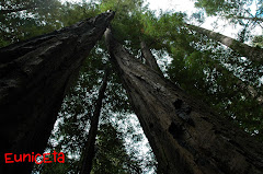
We saw a very huge tree not far after we left Kem Orkid. So huge that we stopped and took some pictures of it.
We saw a very huge tree not far after we left Kem Orkid. So huge that we stopped and took some pictures of it.

Another round of ferns and thorny plants on both sides. As you can see, the climb got a whole lot tougher.

Danny, with his long legs, could have gone much faster, but he slowed down for my twin and I most of the time. Bless you, Danny. :D

The scenery changes as we ascended higher.

It was at this point when all of the sudden we managed to catch up with the people in front. They slowed down because there was this tree with its roots sticking out, blocking our pathway. The roots were sturdy enough and I didn't have much difficulty climbing over it.

12.13PM - Mossy trees surrounding us. Feeling so tired out, always thinking that the peak is just around the corner, I kept asking Danny or the time. Once he said, "according to schedule, we have 10 more minutes to reach the peak." But after 10 minutes, we were still walking. :(

12.19PM - YAY!! WE REACHED THE PEAK!!! It took me 1 hour 36 minutes from Kem Orkid.


We took a lot of group pictures.
1.02PM - We left the peak. It took a REALLY long time getting to Kem Orkid. The descend was slippery. I slipped a few times too.


2.34PM - Left Kem Orkid and reached Sg Kering at 3.14pm. We descended so fast that we had to wait for 20 minutes for the last group to arrive. Danny had a quick snooze too.
3.36PM - We left Sg Kering. The first group went so fast that I couldn't catch up with them. We were just walking straight hoping that we didn't have to turn. The guides were with the 1st and 3rd group.

4.13PM - We were contemplating on whether to stop and wait for the last group when we saw the guide in the first group waiting for us at the turning point. Really, if he didn't wait there, we would have gone straight ahead. There was a signboard there but it wasn't facing us. He said the first group had gone ahead and asked us to wait here for the rest of the group to catch up. We didn't want to wait, so he said he would wait and told us to just follow the winding pathway and it will lead to a flight of metal staircase. He asked us to go down slowly because the stairs weren't in good shape. He said it would take roughly 30 minutes for us to get to the waterfall but it would only take him 10 minutes as he was used to the trail.


I counted about 290 steps before I could see this tall waterfall cascading into a deep pool. It was a beautiful sight, also signifying that we have come to an end of our hike.

Uh.. I will stay it again. The metal staircase were in a REALLY BAD condition. Some of our hikers didn't use the stairs to reach the bottom. They went another way (see arrow above) which is more dangerous because there was nothing to hold and you just have to hope that your shoes grips are good enough so that you won't slip and fall onto the rocks.

The RUSTY metal steps was the other alternative way. The dangling hand railing broke off at the end and we all had to turn our bodies to hold onto the RUSTY metal steps for support as we descend.

Some took off their shoes to cross the river, but I felt that the water level was low enough and I didn't remove my shoes.


The driver stopped his truck to let us take pics of the mountain. He told us that the 'anak hantu' peak was shaped like a princess sleeping and the prince looking towards the 'hantu besar' peak.


We passed by 2 Orang Asli settlements. This is Kampung Tohor Orang Asli settlement. There are roughly about 600 people living here.


7.25PM - We headed to Titi to have our dinner.

Our Hakka dinner. The meal was yummy. My sis noticed an ABC machine and we ordered 2 ABCs. She expressed she wanted to eat ABC when we were hiking up to the peak. Well, looks like she got her wish. :D

The restaurant's name is Sin Wong Kok, just next to the 'Dewan Orang Ramai Titi'. The price was reasonable and we talked of going to Titi, not to climb GBH but to eat there again. :D
----------------------------end of report :D ---------------------------
You can read more about this mountain from a fellow climber's blog.
Facts about this mountain : -
Name : Gunung Besar Hantu (GBH) or Big Ghost Mountain
Height : 1462 meters above sea level.
Tallest mountain in Negeri Sembilan. Border of N.Sembilan and Pahang
Leeches, yes, plenty. :D
Total cost including guide, permit and 4WD - RM53.
Timeline of my climb : -
From Tesco S2, Seremban to Base Camp - 1 hour 40 minutes
From Base camp to starting point via 4WD - 1 hour 3 minutes
From starting point to Sg Kering - 55 minutes
From Sg Kering to Kem Orchid - 1 hour 16 minutes
From Kem Orkid to the peak - 1 hour 36 minutes
From the peak to Kem Orkid - 1 hour 21 minutes
From Kem Orkid to Sg Kering - 40 minutes
From Sg Kering to turn-off point to waterfall - 37 minutes
From turn-off point to metal staircase - 12 minutes
Total ascend time - 3 hours 47 minutes (excluding breaks)
Total descend time - about 3 hours (excluding breaks)
Total ascend time - 4 hours 21 minutes (including breaks)
Total descend time - 3 hours 34 minutes (including breaks)
Direction to base camp -
There are 2 access roads (tarred) to Kg Chennah from the main Jelebu road. Coming from Seremban, take the 2nd access road, which is located a few kilometers further down. It is a much easier and slightly shorter drive. Once we turn into this access road, we will travel for a few kilometers before coming to a round-about, which is under construction. (by the way there are building a new road to Lata Kijang waterfall from Kg Chennah.) Take the 9 o'clock turn. Kem Rumah Bukit is just a short distance in front.


5 comments:
Excellent write up Eunice.Thank you. You did very well, for someone who is not well "prepared". Wow, your ascend and descend time are respectable. By the way, if there is anyone out there who is keen to make this climb, our contact is Encik Adi (hp 013-6121031). His service was excellent and pricing for 4WD and guides were reasonable.This is in comparison to other enquiries I made. We hired 2 guides for our group of 21.
Thanks for a comprehensive report on the climb. :) Now all I have to do is link it to my blog. :)
Jimbo, I was starting to think that you weren't going to to write about GBH. :D
Hey, nice post. Was reading about such climbing experiences when reached jimbocyberdoc's blog. And i reached here from a link there. Simply from the photos it is evident how much fun it must have been. I've only recently taken to mountaineering and trekking. Although such treks are simple enough for anyone without any special training, I'm looking to do more climbing, maybe take a moutaineering training course and try more challenges. I haven't had a chance to be to your part of the world yet. But hop to some day. Keep posting. :)
Thank you for the brief write up. I wish to organise a group to go there for a night camping at the peak. How much to pay for a 4WD to take us for a trip (from base camp to the foothill) and a return trip from lata kijang to the base camp?
Post a Comment